Pix4D
Pix4D orientation and can be used to run SURE's workflow.
Usage:
After processing your Bundle Adjustment / Aero Triangulation using Pix4D, you can export the given results. The given results usually are stored inside the folder "params" inside your Pix4D project.
The exported results compatible with SURE can have either:
Orientation files with *_geocal.txt naming convention for older versions of Pix4D;
Orientation files with *_calibrated_camera_parameters.txt for newer versions of Pix4D.
It is possible to have one file containing the orientation parameters for all your imagery, or you can have separated orientation files for each image.
Structure of a _geocal.txt / _.calibrated_camera_parameters.txt file:
The file is composed of a header and sections
The header states how each section is structured and which information is present
Each picture will have a section, containing the information stated in the header
An example of a _geocal.txt / _.calibrated_camera_parameters.txt file:
fileName imageWidth imageHeight
camera matrix K [3x3]
radial distortion [3x1]
tangential distortion [2x1]
camera position t [3x1]
camera rotation R [3x3]
camera model m = K [R|-Rt] X

DSC00002.JPG 6000 4000
5246.67817210519115178613 0 3014.21699955007488824776
0 5246.67817210519115178613 2056.96346303672453359468
0 0 1
-0.15994587090269449248 0.13993097057610345835 0.00932908149389201011
0.00077353649206159862 -0.00081332657209028754
-892.50251487949105921871 11.21358547207746880758 -4.01732550695115442352
-0.99840813078053458618 -0.01161539151567758145 -0.05519317957190545548
-0.00681563617726710196 0.99623997911544937001 -0.08636811399786505083
0.05598885152258621656 -0.08585445062421988294 -0.99473326164012199069
DSC00003.JPG 6000 4000
5246.67817210519115178613 0 3014.21699955007488824776
0 5246.67817210519115178613 2056.96346303672453359468
Where to find the files:
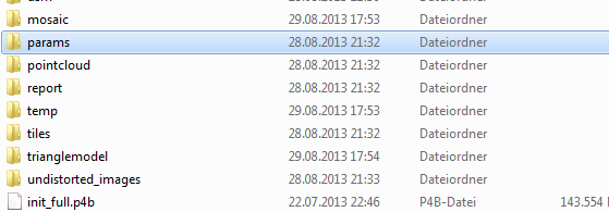
The files are stored in the folder “params” within the project processing directory of Pix4D.
Please pass an image folder with the original imagery.
Note: since the “calibrated_camera_parameters” file does not contain the translation vector in the global coordinate system for large values (e.g. UTM), the file “calibrated_external_camera_parameters” is taken into account as well automatically.
Within a typical Pix4D project processing directory you can find the folder “params”:
There you can either find a file ending with “_geocal.txt” (older versions) or a file with the ending “calibrated_camera_parameters.txt” containing the orientation information:
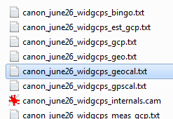
Older versions of Pix4D UAV
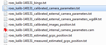
Newer versions of Pix4D UAV
Just drag and drop this file on sure.exe, or run it by using the command line.